Tūtūkākā Coast
Drive through stone wall country to arrive at amazing coves and sandy beaches. Enjoy spectacular seascapes with steep cliffs and deep natural harbours that offer world-class diving, snorkelling, surfing, swimming, fishing and walking. The Tūtūkākā Coast was populated by the Māori people of the Ngātiwai iwi, whose successors live along the coast today and are regarded as the children of the seas.
Ngunguru
This delightful coastal village is perfect to enjoy fish and chips on the beach and a great place for water sports. There is a boat ramp and water ski lane, and you can hire a kayak to paddle the estuary. Enjoy sheltered swimming, playground, golf course, art studios and café.
Ngunguru Sandspit
The pristine Ngunguru Sandspit is one of the few unmodified sandspits remaining in New Zealand. It has significant cultural, spiritual, historical and environmental values, particularly with tangata whenua (indigenous people). You are welcome to visit the spit on foot, but don't take dogs and tread with care. Access is by boat only.
Te Maika Headland
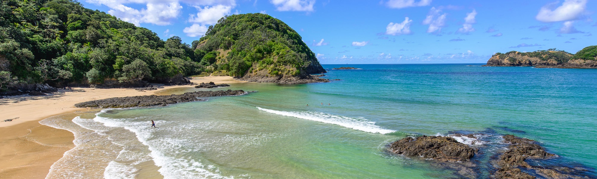
Driving north, turn right into Tūtūkākā Block Road and find your way to a myriad of small secluded bays and beaches including Church Bay, Kowharewa Bay, Pacific Bay, and Whangaumu (Wellington’s) Bay. All these beaches provide easy access, sheltered swimming and launching for your kayak.
Tūtūkākā Marina Village
The Tūtūkākā Marina village lies at the head of a small natural harbour that is a fishing port, coastal waypoint for local and international yachts, and home to charter boats for diving and fishing. There is a general store, dive shop, surf shop and great casual dining and bar options. Outdoor events are often held on the Green.
Saltwater Fishing
Trophies for several world record catches are displayed at the Whangārei Deep Sea Anglers Club. Take your pick of charter boats and choose your fish; marlin, kingfish, snapper, hapuka, kahawai, trevally and tarakihi.
Beaches
A spectacular white sand coastal beach with a sheltered sandy estuary. Grab an ice cream from the store and dig your toes into the sand.
Much-loved by locals, this secluded beach has white sand and a forest-fringed beach. Access is via a short downhill walkway (parking is signposted) through groves of ancient Pūriri trees. Enjoy fantastic swimming and snorkelling in the clear waters and a picnic in the shade of the trees.
This popular coastal beach has easy access from the main road and is great for body surfing and picnics on the grassed areas.
The last beach before you turn inland, Sandy's is is an iconic surf beach suitable for all abilities, but strong rips can form and there is no lifeguarding service so please take care. The south end of the beach is generally more sheltered for swimming.
Walks
Walk between these two bays where from the lookout you’ll have uninterrupted views of Ngunguru Sandspit, Goat Island, Horahora, Pātaua, Taiharuru, and Whangārei Heads.
Get your heart pumping, from the steep climbs and descents as well as the breath-taking views, up and down the stunning Tūtūkākā Coast at the top. The lighthouse is a modest solar powered beacon. Only attempt one hour either side of high tide.
Turn off State Highway 1 and take a break in this quaint rural village. Explore the fascinating karst limestone formations at the Waro Limestone Reserve with limestone formations believed to be 40 million years old. Waro Lake is an old coal mine that has been flooded and is now a popular picnic and swimming spot.
The Hikurangi Museum tells the stories of early settlers and the coal mining industry of 1890. Play a round at the Hikurangi Golf Course with stunning rural vistas, and the nearby Adrenalin Adventure Park has a wakeboarding cable and New Zealand's largest inflatable water course.
If you do one thing on the Tūtūkākā Coast, go to the Poor Knights Marine Reserve. This world renowned marine reserve provides some of the best scuba or snorkel diving you’ll ever do. Even if you don’t want to get into the water, you will enjoy the cruise around the island, hearing the stories of its history and its unique environment, flora and fauna; it's a magic day.
Find Out More Book Your Adventure
Previous Next